The U.S. underground utility locator market in 2026 offers more than instruments that help an operator follow a buried line. Buyers can choose receivers with electromagnetic field diagnostics, configurable frequencies, electronic marker detection, digital logging, and integrated high-accuracy positioning. The procurement challenge is deciding which capabilities solve an actual field problem and which add cost without improving the required deliverable.
Public listings for Vivax-Metrotech utility locators illustrate that spread: older-generation used packages, current cable-and-pipe locating kits, and integrated RTK mapping systems occupy different price points. Those listings are useful purchasing evidence, but they do not establish national market size or brand share.
This review examines manufacturer documentation, federal infrastructure and utility-investigation guidance, historical damage data, and a September 28, 2026 equipment-price snapshot. The central finding is that several available platforms combine detection, diagnostics, and documentation. Evidence of uniform adoption across U.S. contractors is much weaker.
What This Market Review Measures
Three markets are often combined in a headline but need separate treatment: locating equipment, contracted locating services, and subsurface utility engineering. Equipment revenue concerns instruments and accessories. Service revenue also includes labor, mobilization, interpretation, project management, and reporting. A geophysical investigation may use several tools, while a contractor may own one receiver and outsource difficult work.
HDD guidance is another distinct category. A utility locator investigates existing buried infrastructure. An HDD guidance system follows a drill-head transmitter. Both can contribute to a safe crossing, but they answer different questions. Comparing an HDD tracking package with an electromagnetic cable-and-pipe kit would produce a misleading price range.
The review therefore concentrates on U.S. procurement of utility detection and tracing equipment, with mapping and complementary investigation methods included where they change the buying decision. It does not present a dollar valuation of the national market. No transparent, U.S.-specific dataset establishing 2026 unit sales, brand shares, or a comparable growth rate was verified for this review.
Its evidence has three different uses. Manufacturer documents establish published capabilities and operating boundaries. Public listings establish advertised prices for identifiable packages. Government guidance and damage reports establish context for investigation and risk management. None can substitute for the others: an extensive catalog does not prove strong sales, and an infrastructure budget does not measure locator purchases.
Demand Comes From Excavation Risk and Infrastructure Work
Infrastructure construction creates occasions for locating, but the connection to equipment demand is indirect. NTIA describes the Broadband Equity, Access, and Deployment program as a $42.45 billion federal grant program. Its eligible activities extend beyond buried fiber installation. The program allocation is not a measure of spending in 2026, and it should not be converted into a utility-locator sales forecast.
For an equipment buyer, the useful question is more local: which awarded projects involve excavation, what utility information must be delivered, and who performs the investigation? A contractor using a specialist locating subcontractor has a different equipment requirement from a municipality building its own field-mapping capability.
Highway work provides another demand context. FHWA’s July 2026 Every Day Counts guidance treats subsurface utility engineering as a way to investigate utilities early, identify conflicts, and manage information through project development. It references ASCE 38-22 and ASCE 75-22. This supports demand for competent investigation and usable records, not a particular manufacturer or mandatory receiver specification.
Historical damage evidence explains why the workflow matters. The Common Ground Alliance’s 2024 DIRT report presents rounded shares of 25% for failure to notify the one-call center, 16% for failure to maintain clearance after verifying marks, 12% for facilities not marked because of locator error, and 9% for inaccurate marks because of locator error.
These percentages describe categories within historical submitted reports. They are not the probability of damage on a U.S. excavation in 2026. They nevertheless reveal different intervention points: notification, locating, verification, and excavation practice all matter. A more capable receiver cannot repair a notification failure or enforce clearance after a correct locate.
A purchasing case should also consider the wider cost of underground utility strikes, rather than treating the repair invoice as the only exposure. That discussion is useful context for risk budgeting. It does not justify assigning one national average loss to every project or claiming that a new instrument will prevent a fixed number of incidents.
Technology Segments Solve Different Detection Problems
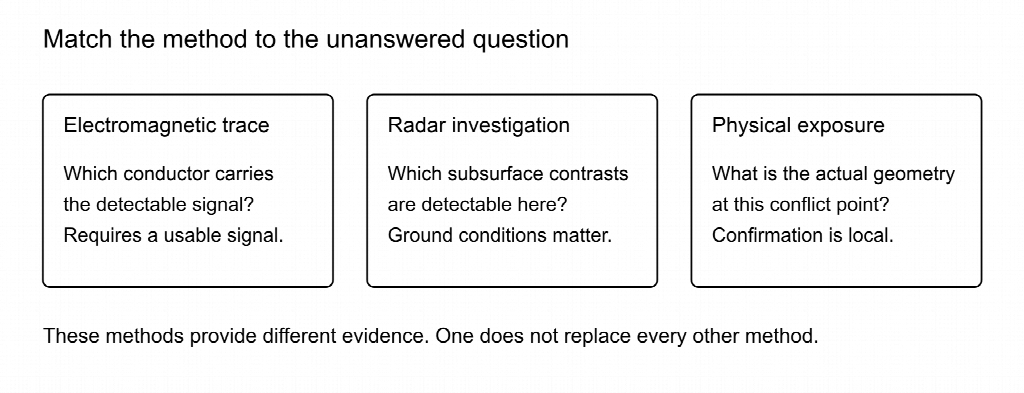
The market is better understood as a collection of methods than as a ladder from inexpensive to expensive equipment. Buying a higher-specification electromagnetic receiver does not give it the physical operating principle of radar or the observational certainty of exposure.
| Method or equipment category | Useful application | Main purchasing boundary |
| Active electromagnetic cable-and-pipe locating | Tracing a conductor or usable tracer wire carrying an applied signal | Target access, continuity, signal application, and field distortion affect the result |
| Passive electromagnetic search | Supplementary search for detectable existing signals | A quiet response does not establish that no utility exists |
| Sonde locating | Finding an inserted transmitter in an accessible pipe or duct | Receiver frequency, sonde compatibility, and access must match |
| Electronic marker locating | Finding installed markers associated with infrastructure | Detecting a marker does not continuously trace the pipe between markers |
| Ground penetrating radar | Investigating subsurface contrasts, including some nonconductive targets | Soil conductivity, target characteristics, depth, and interpretation limit detection |
| Physical exposure and survey | Confirming geometry at a critical utility conflict | Establishes conditions at the exposed point, not the whole alignment |
Sensors & Software describes electromagnetic locating, GPR, and magnetic methods as complementary. Its guidance also explains a central GPR limitation: ground conditions affect penetration. Favorable sandy ground and electrically conductive clay should not be treated as equivalent survey environments. Radar can respond to rocks, disturbed ground, and other contrasts that are not an identified utility.
Procurement should start with the target portfolio. A crew tracing known conductive services needs different accessories from one investigating inaccessible nonconductive lines. A provider mapping a mixed urban corridor may need several methods and an escalation plan, not simply the receiver with the longest feature list.
Specialized variants reinforce this segmentation. Vivax-Metrotech’s vLoc3-ML combines line locating with electronic marker detection, while the vLoc3-XLF is designed for extra-low-frequency long-line work. These are distinct application choices. Their existence does not establish that every buyer needs marker detection or long-line specialization.
Receiver Capability Has Shifted Toward Field Diagnostics
Current receiver documentation describes diagnostics that expose information about the detected field alongside an interpreted line position. This is visible in current product documentation, although the features did not all originate in 2026.
The vLoc3-Pro uses two sets of screened three-dimensional antennas. Its available displays include Vector Locate, Plan View, a graphical sonde screen, and a Transverse Graph showing peak and null responses together. Its configurable frequency range runs from 98 Hz to 200 kHz, alongside eight passive locate modes, Signal Direction, and fault-finding capability.
These features can help an experienced operator investigate an uncertain response. A field-shape display gives additional evidence to interpret. It does not identify every buried asset automatically, and a confidence indicator is not a surveyed error bound. The vLoc3 Series handbook distinguishes green, blue, and red indications associated with increasing distortion and caution.
Frequency Range Must Be Read Alongside Application Mode
A receiver’s frequency range does not mean every transmitter can apply every frequency using every accessory. The Loc3-5Tx technical specification distinguishes direct connection, induction, and clamp application. It lists direct-connection frequencies between 98 Hz and 200 kHz, while the induction and clamp ranges begin at 8.19 kHz.
The same specification describes output limits of 5 W below 45 kHz and 1 W above 45 kHz in accordance with FCC Part 15. Consequently, “5-watt transmitter” is not a promise of 5 W at all listed frequencies. Buyers comparing nominal output ratings should reconcile the frequency, application mode, output limits, and compatible accessories first.
This distinction belongs in an equipment specification. Ask which frequency combinations are available in the supplied configuration, which clamp is compatible, and which options must be purchased separately. A broad configurable range is valuable only when the field procedure and transmitter can use it.
Diagnostics Require an Operating Response
The procurement benefit of a distortion display depends on what happens when it indicates a problem. Training should address when to reconsider the connection, investigate adjacent conductors, compare another supported method, or escalate verification. Otherwise, additional information on the screen may change the appearance of the locate without changing the decision.
FHWA’s geophysical-equipment guidance emphasizes technician knowledge, documented training, and appropriate equipment selection. That is a useful purchasing boundary: a capability demonstration should include how the operator interprets uncertainty, not only how quickly the display finds a signal.
Mapping Integration Is Visible Across Competing Platforms
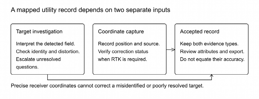
Digital records are no longer confined to one product family. Current manufacturer catalogs show several ways to combine locating with coordinate capture, wireless transfer, and mapping. They differ in hardware, positioning source, application requirements, and correction-service dependencies.
| Published platform | Documented integration | Boundary to verify |
| Vivax-Metrotech vLoc3-Pro | Internal logging and optional Bluetooth for external GPS connectivity | Installed Bluetooth option and actual coordinate source |
| Vivax-Metrotech vLoc3 RTK-Pro | Integrated GNSS, cellular communication, NTRIP corrections, onboard records and cloud transfer | Correction access, communications, positioning status, and output workflow |
| Radiodetection RD8200SG | Integrated GNSS and combined locating/mapping workflow | Cellular data, correction service, and selected mapping solution |
| Subsite UtiliGuard 2 Standard / RTK | Standard includes GPS and Bluetooth; RTK adds high-accuracy mapping | Exact model and required app configuration |
| RIDGID SR-24LE | BLE, integrated GPS, and wireless data transfer | Published GPS accuracy and any external positioning configuration |
The distinction between position capture and utility detection is essential. RIDGID lists an average integrated-GPS accuracy of less than 2.5 m for the SR-24LE. That is a coordinate specification. It is not a statement that the electromagnetic line trace is wrong by 2.5 m, nor a specification of pipe depth accuracy.
Conversely, RTK positioning does not prove centimeter-level subsurface geometry. A receiver can accurately record where it was standing while interpreting the wrong conductor or a distorted field. Buyers should specify coordinate quality and utility-investigation confidence separately.
Vivax-Metrotech’s June 2023 brochure describes MyLocator3 downloads of timestamps, coordinates, depth readings, line current, and notes. It also describes VMMap sharing through KML or CSV. These are documented workflow options, not new 2026 inventions. Current compatibility and required hardware still need confirmation before purchase.
A practical acceptance test should follow a record all the way into the receiving system. Does the required attribute survive the export? Is the coordinate source identifiable? Can a reviewer distinguish measured observations from interpreted geometry? Wireless transfer has little value if the client must reconstruct missing context manually.
A September 2026 Price Snapshot
The following prices were displayed in UCG’s public listings when reviewed on September 28, 2026. They are U.S.-dollar asking prices from one seller, not national averages or completed transactions. Package condition and contents matter more than the apparent spread.
| Stock identifier | Advertised package | Listed condition | Asking price |
| V13 | vLocPro2 with Loc3-5Tx | Used, older receiver generation | $2,299 |
| V12 | vLoc3-Pro with Loc3-5Tx and alkaline transmitter tray | New | $4,890 |
| V10 | vLoc3-Pro with Loc3-5Tx, lithium-ion package | New | $5,530 |
| V1 | vLoc3-Pro with Loc3-10Tx, lithium-ion receiver and transmitter | New | $6,370 |
| V22 | vLoc3 RTK-Pro with Loc3-10Tx and alkaline transmitter tray | New | $11,445 |
The collection also displayed a used vLoc3-Pro/Loc3-5Tx lithium-ion package, V312, at $3,379, marked sold out. That is a catalog observation, not an available offer or proof of a sale at that price.
The Price Gaps Do Not Isolate One Feature
The $1,480 gap between V12 and V1 combines a transmitter change and battery-package differences. It is not the standalone price of higher output. Similarly, the $5,075 difference between V1 and V22 cannot be treated as a clean RTK upgrade price because the listed configurations differ.
An older used vLocPro2 package is also not a discounted new vLoc3-Pro. Its price reflects a different generation and condition. A buyer needs a functionality, support, and condition assessment before using it in an equivalent-cost comparison.
V1 and V12 list direct-connection leads, a ground stake, carrying items, and battery or charging components. Both state that a signal clamp is sold separately. The collection displayed a Vivax-branded five-inch blue-plug clamp, VA2, at $540. Adding that accessory to the $6,370 V1 package gives a $6,910 equipment subtotal before other costs.
Seller Disclosures Affect the Usable Quote
UCG’s collection restricts new-equipment shipping to the Southeast United States. The V22 listing also explicitly states that UCGHDD is not an authorized Vivax-Metrotech distributor. Buyers should therefore obtain written confirmation of shipping eligibility, serial-specific warranty coverage, registration requirements, and service arrangements. A seller’s listing is not proof of manufacturer authorization or warranty entitlement.
The resulting price range demonstrates available procurement routes within this catalog. It cannot establish typical U.S. acquisition cost, manufacturer market share, or a universal used-equipment discount.
Procurement Differs by Buyer and Job Portfolio
An equipment specification should describe recurring tasks and deliverables before it names a preferred instrument. This prevents a low-price package from omitting a necessary component and a premium package from adding capabilities that nobody will use.
For a small excavation contractor, the starting questions are target types, safe access for signal application, operator competence, and access to specialist support. A complete receiver/transmitter/accessory package may matter more than integrated mapping if the work requires dependable local investigation rather than a digital asset deliverable.
For a utility owner or municipality, records can be part of the operating objective. The purchasing discussion should cover who reviews field observations, how they enter the asset system, which coordinate information is accepted, and how updates are distinguished from existing records. Hardware choice follows those requirements.
For a locating-service provider, mixed site conditions make method selection and repeatable training important. Configurable diagnostics may be useful, but fleet rollout also requires consistent settings, available accessories, charging arrangements, and a process for difficult or incomplete locates.
For a subsurface utility engineering provider, the investigation specification is broader than the receiver. FHWA’s quality-level framework distinguishes records, visible-feature correlation, surface geophysics, and physical exposure. A GNSS-enabled locator can support a survey workflow, but buying it does not automatically produce Quality Level A information.
The request for quotation should identify the receiver model, transmitter model, supported application modes, clamp, sondes or marker options, battery arrangements, software options, training, and service route. If digital delivery is required, attach a sample accepted record. That gives competing suppliers the same problem to solve and makes omissions easier to detect.
Adoption Signals Are Not Adoption Statistics
The strongest observable technology signal is convergence: several manufacturers now offer combinations of locating, logging, positioning, and mapping. That establishes product availability and commercial emphasis. It does not reveal how many U.S. crews use those functions or whether clients accept their outputs.
FHWA supplies a more direct, though qualitative, adoption observation. Its July 2026 SUE page states that many states report using subsurface utility engineering but few use it consistently. This concerns an engineering process, not market penetration of RTK receivers. It indicates that available methods and routine institutional use are different questions.
Adoption evidence should therefore be separated into three levels. First is availability: a supplier offers the capability. Second is operational use: an organization deploys it in real work. Third is accepted outcome: the resulting investigation or record meets the recipient’s requirements. A procurement announcement proves less than a documented rollout, and a rollout proves less than consistent deliverable acceptance.
For a contractor evaluating an investment, internal measurements may be more useful than an unsupported national adoption percentage. Track repeat visits, rejected records, time spent reconstructing field information, difficult-locate escalation, and equipment unavailability. Compare like-for-like work where possible, rather than attributing every improvement after purchase to the new receiver.
This does not make market analysis impossible. It changes the question from “How fast is everyone buying?” to “Which capabilities are available, which requirements are changing locally, and which benefits can this operation verify?”
Total Ownership Cost Changes the Price Comparison
Purchase price is only one part of usable ownership cost. Accessories, commissioning, service, temporary equipment, data integration, and communications can change the comparison. The appropriate horizon should be the same for each option, and both options must satisfy their intended technical requirements.
The table below is a hypothetical three-year, undiscounted planning example. Only the kit prices and $540 clamp reference come from the observed listings. All other amounts are illustrative allowances, not supplier quotations, measured failure costs, or expected savings.
| Cost component | Conventional locating workflow | RTK mapping workflow |
| Listed kit purchase | $6,370 | $11,445 |
| Clamp reference | $540 | $540 |
| Assumed training and commissioning | $1,200 | $1,600 |
| Assumed maintenance allowance | $900 | $900 |
| Assumed temporary-equipment allowance | $1,200 | $1,200 |
| Assumed data integration | $0 | $1,200 |
| Assumed correction/connectivity allowance | $0 | $2,400 |
| Illustrative three-year total | $10,210 | $19,285 |
The illustrative gap is $9,075. At an assumed internal labor value of $75 an hour, that corresponds to 121 hours across three years. This is a way to test the scale of a purchasing case, not a claim that mapping will save those hours. The operation would need evidence of useful time reduction or a required additional deliverable.
The comparison is also not a substitute for technical fit. If the contract requires a mapping output the conventional workflow cannot deliver, it is not an equivalent solution unless the cost of separate surveying and integration is added. If no usable mapping output is needed, assigning a value to unused RTK functionality would be equally misleading.
Sensitivity changes the answer. Halving the assumed $2,400 correction/connectivity allowance lowers the mapping total to $18,085 and the gap to $7,875. A supplier quote may bundle some services differently. Training and data setup may also be organized centrally for a fleet rather than charged to each instrument.
The example excludes taxes, freight, financing, discounting, resale credits, and damage-avoidance benefits. In particular, it assigns no probability that an equipment purchase prevents a utility strike. A defensible business case should use the company’s own costs and verifiable workflow outcomes, not a large hypothetical incident saving chosen to make the purchase attractive.
Field Acceptance Should Precede Fleet Rollout
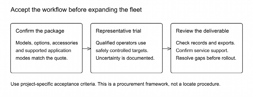
A demonstration should test the required work, including conditions that expose limitations. Use a safely controlled site with independently established targets and appropriately qualified personnel. A sales demonstration on one convenient line cannot establish performance across a mixed work portfolio.
The following acceptance sequence is a procurement recommendation, not a manufacturer procedure or universal accuracy test:
- Reconcile the delivered package against the written inventory, including options, accessories, serial numbers, and charging equipment.
- Confirm supported receiver/transmitter frequencies and application modes against the documentation for those exact models.
- Have intended operators perform representative tasks under the applicable safety procedures, not just observe a specialist demonstrator.
- Examine how the workflow handles uncertain or distorted responses and whether escalation decisions are recorded.
- If mapping is required, export representative observations into the actual receiving system and review the resulting attributes and coordinate information.
- Confirm service contacts, warranty terms, software compatibility, training arrangements, and temporary-equipment options before accepting a fleet rollout.
The acceptance criteria should come from the project or asset owner. An equipment brochure should not become a substitute for those criteria. Keep records of conditions, configurations, operator experience, and unresolved observations so that a later comparison remains meaningful.
Federal excavation requirements remain separate from purchase acceptance. OSHA 1926.651(b) addresses utility estimation, owner contact, and determination of exact location by safe and acceptable means as excavation approaches an installation. A successful equipment trial does not waive those duties or establish a universal tolerance-zone distance.
Where Additional Methods Remain Necessary
Modern diagnostics improve the information available to the operator, but procurement must preserve a route for questions the receiver cannot resolve. In a mixed corridor, a clear conductive trace may coexist with an untraceable plastic service. Accurate coordinates cannot fill that detection gap.
The FHWA framework helps distinguish the evidence. Quality Level D relies on records. Quality Level C correlates surveyed visible features with records. Quality Level B uses appropriate surface geophysical investigation. Quality Level A requires actual exposure and measurement, generally at specific points. These describe how utility information was obtained, not tiers of equipment price.
A review of how different locating methods reduce uncertainty is useful when planning escalation. The decision should follow the unanswered question: target identity, missing utilities, horizontal alignment, depth, or the actual clearance at a conflict.
Consider an illustrative crossing with a traced conductive line and a nearby service shown only in an old record. Repeating the first line’s coordinate measurement does not investigate the second service. A different method may add relevant evidence, and a critical conflict may still require physical exposure. Even then, one exposed point does not establish the route and elevation everywhere between test holes.
This is a resource-planning issue as well as a technical one. A contractor need not own every method, but should know who can provide the missing investigation and how it is authorized. A locator purchasing plan that leaves no allowance for specialist work or critical-point verification is incomplete, regardless of receiver sophistication.
What Buyers Should Watch Next
The most useful forward-looking indicators are specific enough to change an equipment specification. Watch whether local clients require coordinate-based deliverables, whether those requirements distinguish positioning quality from detection confidence, and whether field records are actually incorporated into asset systems.
Supplier evidence should also be checked at the level of the supported configuration. Product names can remain familiar while options, applications, service arrangements, and package contents differ. An available download does not prove repair parts or manufacturer warranty coverage for a particular serial number.
Fleet managers can monitor accepted records, rework, difficult-locate escalation, and support interruptions after deployment. A useful review compares similar tasks and explains changes in staffing or site conditions. It should not report speed alone if faster work creates additional callbacks or incomplete records.
For market observers, repeat procurement requirements and documented field use are stronger indicators than a growing number of mapping-enabled product pages. Published transaction data would improve price analysis, while a transparent U.S. installed-base survey would improve adoption analysis. Until those are available, scoped catalog observations and qualitative institutional evidence should retain their labels.
The Practical Market Conclusion
The U.S. utility-locator market in 2026 presents a broad set of available capabilities: configurable electromagnetic tracing, field diagnostics, specialized target functions, digital logging, and several routes to integrated positioning. Public equipment listings also show distinct acquisition choices across generation, condition, transmitter configuration, and mapping capability.
Those observations support practical procurement decisions, not a national sales forecast. The reviewed prices belong to identifiable packages from one seller. Manufacturer features establish what a configured system is designed to do, while historical damage data and FHWA guidance explain why the surrounding investigation process remains essential.
The strongest purchasing approach begins with targets and deliverables, compares complete supported packages, tests the intended workflow, and keeps independent verification available where consequences demand it. The best investment is the configuration whose capability, records, support, and total cost fit the work that the buyer can actually demonstrate.