A practical guide to site plans, location plans, scales, boundaries and the checks that can help avoid unnecessary planning delays.
Submitting a planning application can feel like a paperwork exercise, but the supporting drawings and plans are often just as important as the application form itself. If a plan is missing, unclear or prepared at the wrong scale, the local planning authority may request corrections before the application can progress.
One of the most commonly misunderstood documents is the site plan for a planning application. It is often confused with a location plan, a block plan or an architectural drawing. Although these documents may be requested together, each one serves a different purpose.
Understanding what is required before submitting an application can save time, reduce avoidable delays and give the planning officer a much clearer picture of the proposed work.
What is a Site Plan?
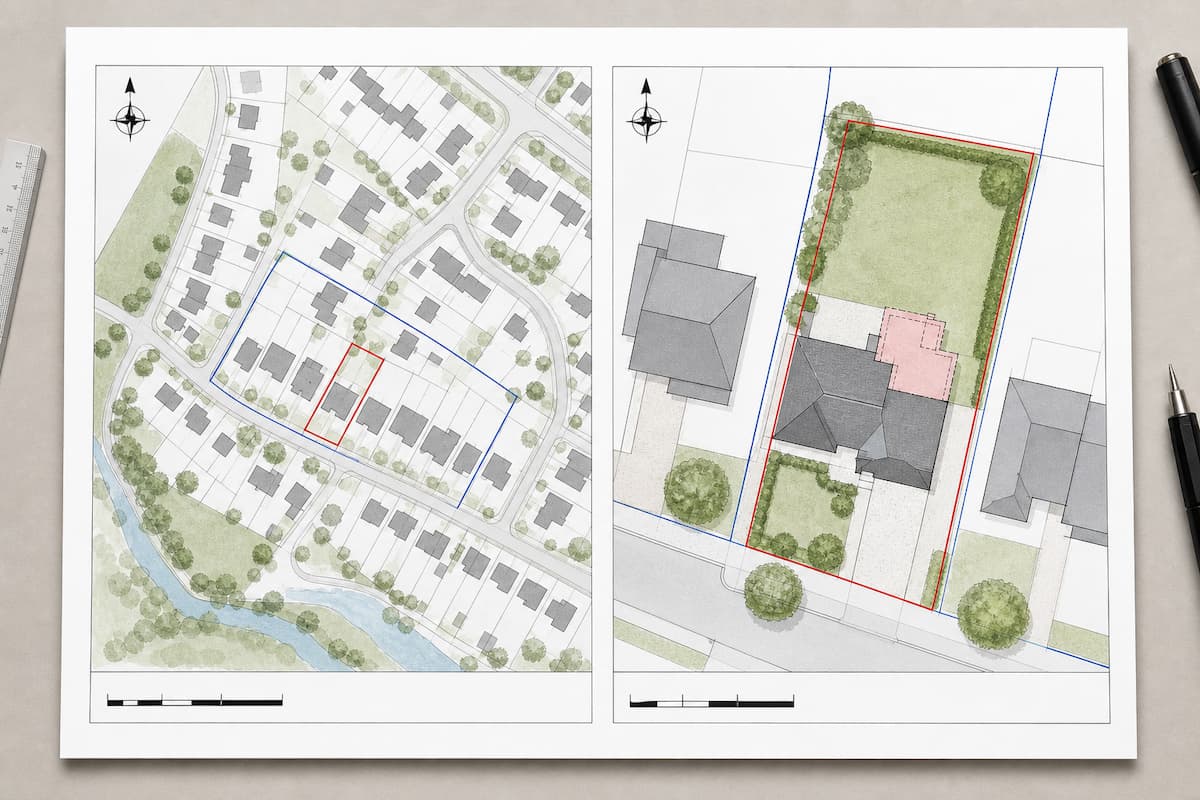
A site plan is a scaled, top-down drawing showing a property and the land immediately around it. It helps the planning authority understand where the proposed development will sit in relation to existing buildings, boundaries, access points and neighbouring land.
For example, a site plan might show the position of a proposed extension, garage, garden room, driveway, new access or outbuilding. It can also show relevant features such as walls, fences, trees, parking areas, paths and nearby buildings.
The exact information required depends on the type of application and the local authority. However, a site plan will normally need to be clear, accurately scaled and based on current mapping. It should also include a north point and a scale bar so that the drawing can be interpreted correctly, whether it is viewed on screen or printed.
A site plan is sometimes referred to as a block plan or site layout plan. The terminology varies between councils and application forms, so applicants should always check the document checklist issued by their local planning authority.
Site Plan Versus Location Plan
The distinction between a site plan and a location plan causes considerable confusion.
A location plan shows the wider area surrounding the application site. It identifies where the property is located in relation to nearby roads, buildings and other landmarks. It is usually produced at a smaller scale, commonly 1:1,250 or 1:2,500.
A site plan provides more detail. It focuses on the property itself and the immediate surrounding area. It is commonly prepared at a scale such as 1:200 or 1:500, depending on the size of the site and the level of detail required.
In simple terms, the location plan answers the question, Where is the site? The site plan answers the question, What is happening on the site?
Many planning applications require both. The location plan gives the proposal context, while the site plan allows the planning officer to understand the relationship between the proposed work, the existing property and neighbouring land.
What Should a Site Plan Show?
The contents will vary depending on the proposal, but a useful site plan may include: • The existing property and nearby buildings
• The proposed development clearly identified
• Site boundaries and ownership information
• Roads, driveways and pedestrian access
• Parking spaces and turning areas
• Walls, fences and other boundary treatments
• Trees and significant landscaping
• Footpaths or public rights of way
• The position of neighbouring properties
• A north arrow and scale bar
• The drawing scale and a unique plan reference
The proposed work should be easy to distinguish from the existing layout. For example, a proposed extension should not blend into the outline of the existing building. Clear labels, a legend and contrasting line styles can make the drawing much easier to assess.
The red-line boundary is also important. It should normally include all the land required to carry out the development, including relevant access, parking, landscaping and other areas associated with the proposal. If additional land in the applicant’s ownership is nearby but outside the application site, it may need to be identified separately.
Why Scale and Mapping Matter
A planning drawing is not simply a screenshot of an online map. It needs to be prepared using an appropriate scale and a suitable mapping source.
If a plan is enlarged or reduced after it has been created, the printed scale may no longer be accurate. This is why applicants should check that the scale bar remains correct and that the plan is printed at its intended size.
Mapping should also be current and properly licensed. The government’s planning guidance explains that plans should be drawn to an identified scale and include a direction of north. It also recommends using an up-to-date map that clearly identifies the application site and its surroundings.
Some councils specifically require Ordnance Survey-based plans with the relevant copyright and licence information displayed. Using an unlicensed map or an unsuitable online image can create problems during validation.
Common Mistakes to Avoid
Several straightforward mistakes can lead to a plan being rejected or returned for amendment.
The first is using the wrong document. A location plan alone may not provide enough detail to show the proposed development. Conversely, a detailed site plan may not show enough surrounding context to identify the property clearly.
Another common problem is an incomplete red-line boundary. If the boundary excludes a required access route, parking area or part of the garden affected by the proposal, the application may not accurately describe the development site.
Incorrect scale is another issue. A plan that looks clear on a computer screen may be misleading when printed. Applicants should check the final PDF at 100% size and confirm that the scale, north point and plan references are visible.
It is also worth checking whether the local authority requires existing and proposed versions. Some applications need the current layout and the proposed layout to be shown separately, while others may require additional drawings such as elevations, floor plans or a landscaping plan.
How to Obtain a Site Plan
Homeowners and small builders have several options. An architect, planning consultant or architectural technician may prepare the plans as part of a wider service. Alternatively, applicants can use an online mapping provider to create and download a plan for the specific address.
When choosing an online service, check that it provides the required scale, a suitable mapping source, a clear boundary and the information needed by the relevant planning authority. It is also sensible to confirm whether the finished plan is supplied as a correctly sized PDF suitable for online submission.
For applicants who need a straightforward mapping document, creating a site plan online can be a practical way to identify the property, mark the application boundary and prepare a downloadable plan without commissioning a full set of architectural drawings.
However, a site plan does not replace professional planning or design advice. Larger, complex or sensitive proposals may require input from an architect, surveyor or planning consultant.
Final Checks Before Submission
Before uploading a site plan, review the local authority’s validation checklist. Confirm that the plan is based on current mapping, the correct site is outlined, the scale is accurate and the north point is shown.
Check that the proposal is labelled clearly and that all land needed for the development is included. Make sure the PDF is legible when printed and that any required copyright, licence or plan-reference information is visible.
A well-prepared site plan will not guarantee planning permission, but it can help the application start from a stronger position. It gives the planning authority a clear understanding of the site, reduces ambiguity and makes it easier to assess the proposal alongside the other application documents.
For many homeowners and builders, preparing this document carefully is one of the simplest ways to avoid an unnecessary planning delay.